2.3. Inundation Models
2.3.1. Simple Inundation (HAND method)
Height Above Nearest Drainage (HAND) method proposed by Rennó et al. (2008), considers relative flow depth to fill a hydro-conditioned DEM. The methodology could be used to obtain quick results, but has some limitations as the listed ones (Aristizabal et al., 2023):
Doesn’t consider pluvial, coastal, ground water, and dam break components among other possible.
Inundation proxy or no physics model.
Requires all areas eligible for inundation to drain to the designated drainage network (Hydro-conditioning).
Higher resolutions can lack sufficient representation of fine grain features such as embankments, flood walls, and closure structures.
The following figure illustrates the implementation of the HAND methodology using EF5.
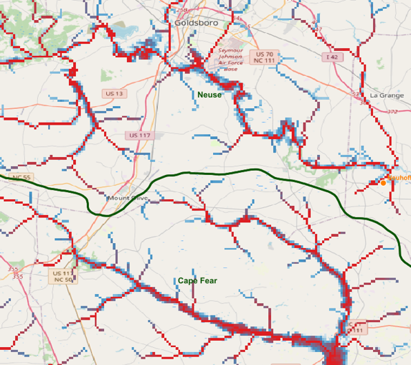
Water depth (.tif) output using EF5. The arbitrary color ramp represents the water depth for the simulated event.
The following figure briefly illustrates the implementation concept of HAND.
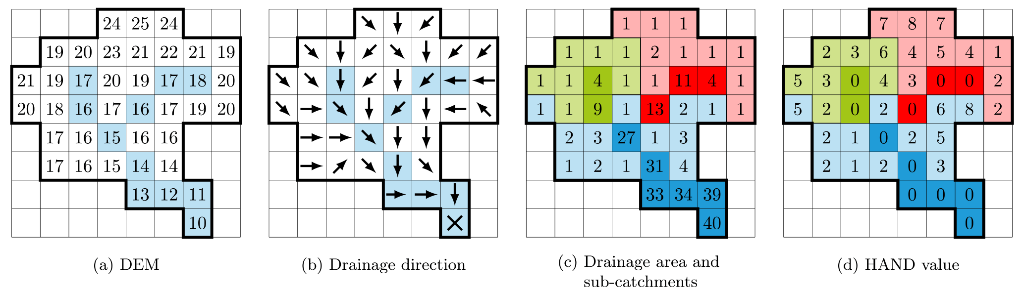
HAND methodology implementation, from (Rebolho et al., 2018)
2.3.1.1. Simple Inundation Parameter Set
Defines the parameters for the simple inundation model. The parameters alpha and beta are used to define the coefficients for the rating curve power function, which is used to calculate the flow depth from the simulated flow rate.
- PARAMETERS FOR INUNDATION
gauge: Gauge ID as defined in the BASIN block.alpha: Lumped parameter for the rating curve alpha*(discharge)^beta. If using distributed parameters, it will work as a multiplier factor for the grid values.beta: Lumped parameter for the rating curve alpha*(discharge)^beta. If using distributed parameters, it will work as a multiplier factor for the grid values.th_fim: Flow accumulation threshold to estimate the inundation area. This parameter is independent of the routing model thresholdth. v 1.2.6 and later. Previous versions use thethparameter as the threshold for inundation.Optional parameters:
alpha_grid: Path for the grid of alpha parameter (.tif) for the rating curve alpha*(discharge)^beta. It must be accompanied by thealphaparameter, which will work as a multiplier factor for the grid values.beta_grid: Path for the grid of beta parameter (.tif) for the rating curve alpha*(discharge)^beta. It must be accompanied by thebetaparameter, which will work as a multiplier factor for the grid values.
- OUTPUT GRIDS
MAXINUNDATION: Maximum inundation depth (m) for the simulation period. (v 1.2.4 and later)INUNDATION: Inundation depth (m) at each time step.HANDCATCHMENT: HAND catchment areas (v 1.2.6 and later)
Example of Simple Inundation control file
...

[simpleinundationparamset rundufim]
gauge=rundu
alpha_grid=parameters/alpha_fim_rundu.tif
beta_grid=parameters/beta_fim_rundu.tif
alpha=1                    # Multiplier factor for the grided parameter
beta=1                     # Multiplier factor for the grided parameter
th_fim=1000                # v 1.2.6 and later

[Task SimulationRundu]
...
inundation=simpleinundation
inundation_param_set=rundufim
output_grids=INUNDATION|MAXINUNDATION|HANDCATCHMENT
...

[Execute]
TASK=SimulationRundu
Warning
🚧 This documentation is currently under active development. Content may change frequently and some sections may be incomplete.